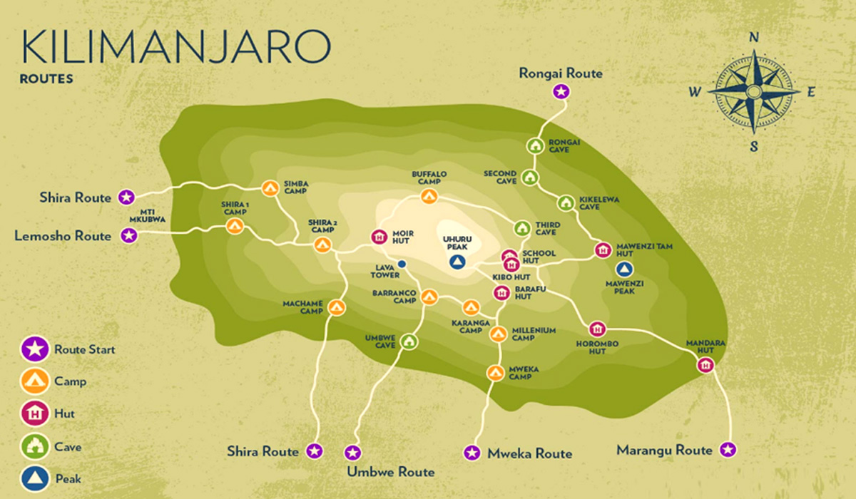
Experience the Ultimate Kilimanjaro Climb
and Tanzania Safari adventure.

Kilimanjaro Map

Kilimanjaro Map

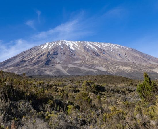
A sense of adventure will take hold as you look at the Kilimanjaro Map unfurled before you. This is the world’s highest free-standing mountain, approximately 19,341 feet (5,895 meters). The snow-capped summits of the mountain stand in distinct contrast to the encircling savannahs, calling out the names of courageous climbers to accept the challenge of scaling its summit.

With the help of our following Kilimanjaro Map, you can track the winding trails of the mountain and take a plunge into its rich landscapes and natural beauty.

Quick Navigation Links

Some Quick Facts On The Kilimanjaro Map

Before we dive into the fundamentals of Kilimanjaro’s Map and its surrounding richness, let’s first take a peek at some quick facts that will enhance your Mount Kilimanjaro Climbing experience:

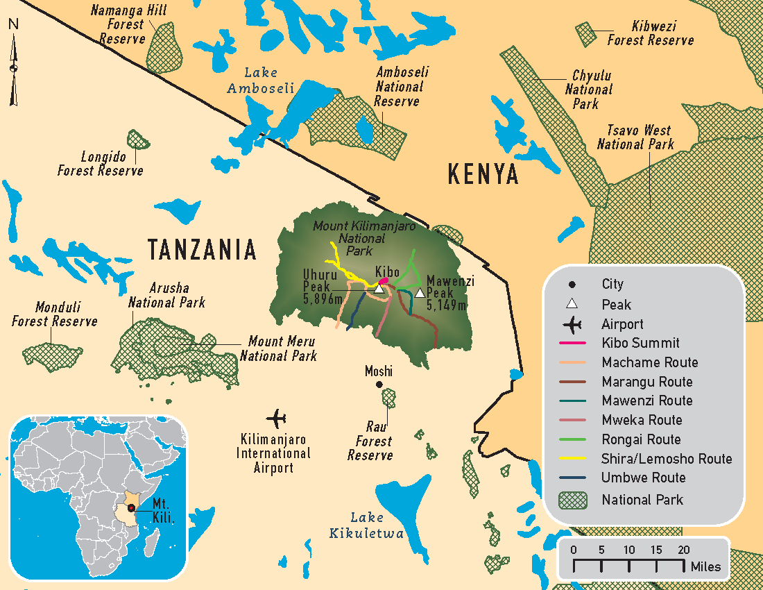
Location – Mount Kilimanjaro is located in the Kilimanjaro region of Tanzania and is situated at a sea level of above 5,895 metres (19,341 ft.) and around 4,900 metres (16,100 ft.) above the base of the plateau.

Elevation – 5,895 metres (19,241 ft.)

Coordinates – 03°04′33″S 37°21′12″E

Altitude Zones – Mount Kilimanjaro is divided into various altitude zones. This includes the cultivation zone, rainforest zone, heath and moorland zone, alpine desert zone, and the arctic zone.

Nearby Towns – The major towns and cities near Mount Kilimanjaro are Moshi, Arusha, and Dar es Salaam.

Surrounding Mountains – Mount Kilimanjaro is part of the Kilimanjaro Mountain range which has other mountains like Mount Meru and Mount Ol Doinyo Lengai.

Routes – Seven primary Mount Kilimanjaro Routes are used to scale the mountain. These include the Machame Route (Whiskey Route), Marangu (Coca-Cola Route), Lemosho Route, Rongai Route, Shira Route, Umbwe Route, and the Northern Circuit Route.

The Importance Of Using Kilimanjaro Map

Kilimanjaro Maps are essential in ensuring a successful and fulfilling trek up Africa’s highest peak. Its importance is highlighted below:

  • Map of Kilimanjaro helps identify the correct route suitable for one’s physical fitness and climbing experience.
  • Highlights critical acclimatization points essential for altitude adjustment.
  • Offers insights into potential terrains, assisting in gear preparation.
  • Assists in understanding the geographical context, placing Mount Kilimanjaro on Africa Map.
  • It provides a comprehensive view of various camps and stops essential for planning resting periods.

Using a Mount Kilimanjaro Map paves the way for a safer climb and enriches the trekking experience. Having a clear map aid in well-informed decision-making, ensuring an exciting journey up this majestic peak.

Kilimanjaro Altitude Zones

Kilimanjaro is divided into five distinct altitude zones, each with its unique characteristics and challenges. These altitude zones are briefly explained below with an overview of their characteristic features:

ZONE

ALTITUDE RANGE (in Metres)

CHARACTERISTICS

Cultivation

800-1,800

Farming and vegetation

Rainforest

1,800-2,800

Dense forest, rich biodiversity

Heath and Moorland

2,800-4,000

Low shrubs, grasses, and mosses

Alpine Desert

4,000-5,000

Barren landscape, rocky terrain

Arctic

5,000-5,895

Glaciers, snow, and ice

Kilimanjaro Habitats

Mount Kilimanjaro is home to a wide range of habitats, each possessing a unique diversity of flora and fauna. The mountain is known for its geographical features, ranging from lush rainforests to barren alpine deserts.

As you ascend the mountain, you’ll pass through different vegetation zones, each with its unique characteristic. The lower slopes are home to dense rainforests, while the higher elevations are characterized by moorlands, heathlands, and alpine deserts. Let’s see them in a detailed manner:

HABITAT

ALTITUDE RANGE (METERS)

CHARACTERISTICS

Rainforest

1,800-2,800

Trees, shrubs, and ferns

Heath

2,800-3,500

Heather and lobelia

Moorland

3,500-4,000

Grasses and heath

Alpine Desert

4,000-5,000

Scattered shrubs and lichens

Glaciers

Above 5,000

Snow and ice

The Peaks of Mount Kilimanjaro

Kilimanjaro has three main peaks: Uhuru Peak, the highest point on Kibo; Mawenzi, a jagged peak with several secondary summits; and Shira, a plateau that was once a volcanic cone. Here is an overview of the peaks on Kilimanjaro:

PEAK

ALTITUDE (METERS)

CHARACTERISTICS

Uhuru Peak

5,895

The highest point on Kibo, the main peak of Kilimanjaro

Mawenzi

5,149

Jagged peaks with several secondary summits

Shira

3,962

A plateau that was once a volcanic cone

The Kilimanjaro Route Map

Climbers can utilise seven Mount Kilimanjaro Routes to ascend to Uhuru Peak. Each route has its distinct characteristics and challenges to overcome. Here is an overview of the routes on Kilimanjaro:

ROUTE

DIFFICULTY

POPULARITY

SCENERY

Marangu

Low

High

Less scenic than other routes

Machame

Medium

High

Beautiful scenery and varied terrain

Lemosho

Medium

Medium

Scenic, remote, and less crowded

Rongai

Low

Low

More remote, less scenic than other routes

Northern Circuit

High

Low

Remote and scenic

Umbwe

High

Low

Stunning vistas all along the trail

Shira

Medium

Low

Fantastic scenery, but you will miss the rainforest section

Explore our links to see all the package details. Please write to us, if you have any further questions or need additional information. We’re here to help!

Dynamic Map Of Kilimanjaro

Below is an interactive Google map of Mount Kilimanjaro in the world.

Resourcefulness and Preparedness with Kilimanjaro Map!

In summary, a Kilimanjaro Map is a valuable resource for planning and preparing for a climb to the summit. With its unique geographical aspects, altitude zones, habitats, peaks overview, and routes overview, the Kilimanjaro Map will aid you on your climbing quest. And with careful planning, proper gear and supplies, and the right mindset, anyone can conquer this magnificent mountain and experience breathtaking views from the top.

the most awaRded adVentuRe

tour operator in kilimanjaro

We are proud of our 100+ reviews on Tripadvisor, the largest tour review website.

Kilimanjaro Preparation

Kilimanjaro Altitude Sickness
Kilimanjaro Altitude Sickness which occur the height.
Best Time To Climb In Kilimanjaro
As a perfectly balanced weather, from January.
Kilimanjaro Tipping Guide
Tipping is a compulsory tradition on every
Kilimanjaro Porters
Kilimanjaro Porters and Guides have the major role to make your Kilimanjaro.
Kilimanjaro Faqs
The base age limit set by Kilimanjaro National Park for kids trekking.
Training For Kilimanjaro
Mount Kilimanjaro is the highest peak and needs.
Kilimanjaro Guide
Despite being the most accessible mountain peak for the summit, many hikers.
Kilimanjaro Foods
Kilimanjaro Porters and Guides have the major role to make your Kilimanjaro.
Electronics Gadegts
With our years of mountain experience.
Kilimanjaro Gear List
Kilimanjaro Gears plays a vital role in climbing highest.
Routine For Kilimanjaros
Summit the majestic Kilimanjaro
How To Plan Kilimanjaro Climb
Conquering Africa’s biggest mountain, Mt Kilimanjaro.
Acute Mountain Sickness
Kilimanjaro Climb Cost
There’s not a definitive answer out there as to what.
Kilimanjaro Daypack
Technical backpacks designed specifically with Climbing Kilimanjaro
Kilimanjaro Flights
Conquering Africa’s biggest mountain, Mt Kilimanjaro.
Climbing Kilimanjaro for Beginners
Newbie climbers often have a significant question .
Kilimanjaro Full Moon Climb
Summiting Kilimanjaro is an adventure full of excitement.
Kilimanjaro Health Check
Africa’s biggest mountain, Mount Kilimanjaro
Kilimanjaro Map
As you look at the Kilimanjaro Map unfurled before you
Kilimanjaro Rescue
There is a dedicated Kilimanjaro Rescue Team that
Kilimanjaro Safety
Climbing Mount Kilimanjaro can be a thrilling experience.
Climbing Kilimanjaro Solo
Climbing Africa’s biggest mountain, Mount Kilimanjaro
Kilimanjaro Success Rate
Every hiker in this world dreams to reach the top of Kilimanjaro
Kilimanjaro Summit Preparation
Climbing Africa’s tallest Mountain, Kilimanjaro
Kilimanjaro Tents
Resting in the Kilimanjaro Tents is a dream come true
Kilimanjaro Trail Conditions
Looking to conquer the majestic Mount Kilimanjaro?
Kilimanjaro Travel Insurance
Looking to conquer the majestic Mount Kilimanjaro?
Kilimanjaro Vaccinations
There are no obligatory Kilimanjaro Vaccinations
Sleeping Bags On Kilimanjaro
Resting in the Kilimanjaro Tents is a dream come true
Lodges In Kilimanjaro
Be prepared for a trek through a variety of terrains
Kilimanjaro Weather
Being conscious of Kilimanjaro Weather before your tour up the mountain
Thing To Do Before Kilimanjaro
Being conscious of Kilimanjaro Weather before your tour up the mountain

Two Decades of Unparalleled Experience

Kilimanjaro Map Faq's

It is recommended to use a topographical map that shows the terrain, elevation, and routes of Kilimanjaro.
Yes, there are free Kilimanjaro maps available online. However, they may not be as detailed as paid maps.
A Kilimanjaro map typically shows the location of campsites, water sources, trails, routes, and landmarks.
The scale of a Kilimanjaro Map varies, but it is usually between 1:50,000 and 1:75,000.
While a GPS can be useful, it is recommended to use a map as a backup and for navigation in case of battery failure or technical issues.
Yes, there are different maps for the various Kilimanjaro routes, such as the Marangu, Machame, and Lemosho routes.

SEE WHO TRUSTED US!

Pizza Hut Breaks World Record with Trusted Delivery Partner, Tanzania Tribe Safari, (aka) summit trails.

Customer Reviews

4.9 Out Of 5 Stars From 47 Reviews

TOP ROUTES IN KILIMANJARO

Welcome you to explore some of the untouched routes of Kilimanjaro

Lemosho Route

Mt Kilimanjaro Lemosho Route is renowned for its varied terrains, presenting climbers with the perfect blend of beauty and challenge. From wandering through lush forests to capturing stunning sunrises and sunsets, the hikers witness picturesque landscapes. Moreover, this Lemosho Route Kilimanjaro has become particularly popular due to its high success rate. Trekkers opting for this Kilimanjaro Route have a notably increased chance of reaching the summit.

Shira Route

Shira Route is a stunning and less travelled trail to the summit of Mount Kilimanjaro, starting at an altitude of 3,600 meters on the Shira Plateau. The route offers diverse scenery, from high-altitude desert landscapes to lush rainforests.

Machame Route

The Mt Kilimanjaro Machame Route is celebrated for its stunning beauty, diverse landscapes, and well-structured acclimatization process. Though similar to the Lemosho Route in many aspects, the Machame trail distinguishes itself by its unique paths on the first couple of days.

Rongai Route

The Rongai Route, unique in its approach from Kilimanjaro’s north side, offers a distinct climb experience. This route is particularly favourable for trekkers considering a climb during the rainy months, given the area’s lesser rainfall.

Lemosho Route

7-9 Days Starting From

$1950

Shira Route

6-9 Days Starting From

$1920

Machame Route

6-7 Days Starting From

$1900

Rongai Route

6-8 Days Starting From

$1902

WHY TRAVEL WITH US?

We are passionate about Tanzania. We’ll show you Tanzania, better than anyone else.

Over 30 Years Experience

Because of which we endeavour to push our limits and surpass their desire by giving them the most paramount climbing & safari experience of their lifetime.

Local Experienced Guides

The significance of having capable, high quality guides and porters can't be exaggerated with regards to climbing Mount Kilimanjaro. Tanzania Tribe Safari utilizes.

Award
Winning

Tanzania Tribe Safari is a full registered local company operated under travel and hospitality rules and regulation of Tanzania governments.We take care of every details.

Over 30 Years Experience

Because of which we endeavour to push our limits and surpass their desire by giving them the most paramount climbing & safari experience of their lifetime.

the most awaRded adVentuRe

tour operator in kilimanjaro

We are proud of our 100+ reviews on Tripadvisor, the largest tour review website.

BLOG & NEWS

Latest News & Updates About Tanzania Safari & Climbing

Two Decades of Unparalleled Experience

Kilimanjaro Guides Faq's

Kilimanjaro guides are highly experienced professionals who provide valuable assistance in navigating the mountain's various routes, providing critical knowledge about the terrain, weather, and potential hazards. They can also offer guidance on pacing and adjust to the altitude, which can be especially important for climbers who are not accustomed to high-altitude environments.
Most Kilimanjaro guides speak English, which is the primary language used on the mountain, but they may also speak other languages, such as Swahili.
Tipping Kilimanjaro Climb guides is customary and typically based on the quality of service provided. The recommended tipping amount is around $20-$25 per day, per the guide. Tipping is usually done at the end of the climb.
While it is technically possible to Climb Kilimanjaro without a guide, it is highly recommended to hire a licensed Kilimanjaro guide for safety and to comply with Tanzanian park regulations. The guides are trained to handle emergencies and provide a safe climbing experience.
Kilimanjaro guides take a range of safety measures, including monitoring climbers for signs of altitude sickness, ensuring proper acclimatization, and providing emergency medical assistance if needed. They also carry equipment such as radios, oxygen tanks, and first-aid kits, and are trained to handle a range of emergencies.
The number of guides needed for Kilimanjaro climbing depends on the size of the climbing group, the route, and the specific park regulations. Typically, a group of two to three climbers will have one guide, while larger groups may require more, Mt Kilimanjaro guides.

SEE WHO TRUSTED US!

Pizza Hut Breaks World Record with Trusted Delivery Partner, Tanzania Tribe Safari, (aka) summit trails.

Customize Your Travel To Tanzania
© 2025 All Rights Reserved. Tanzania Tribe Safaris